.svg)
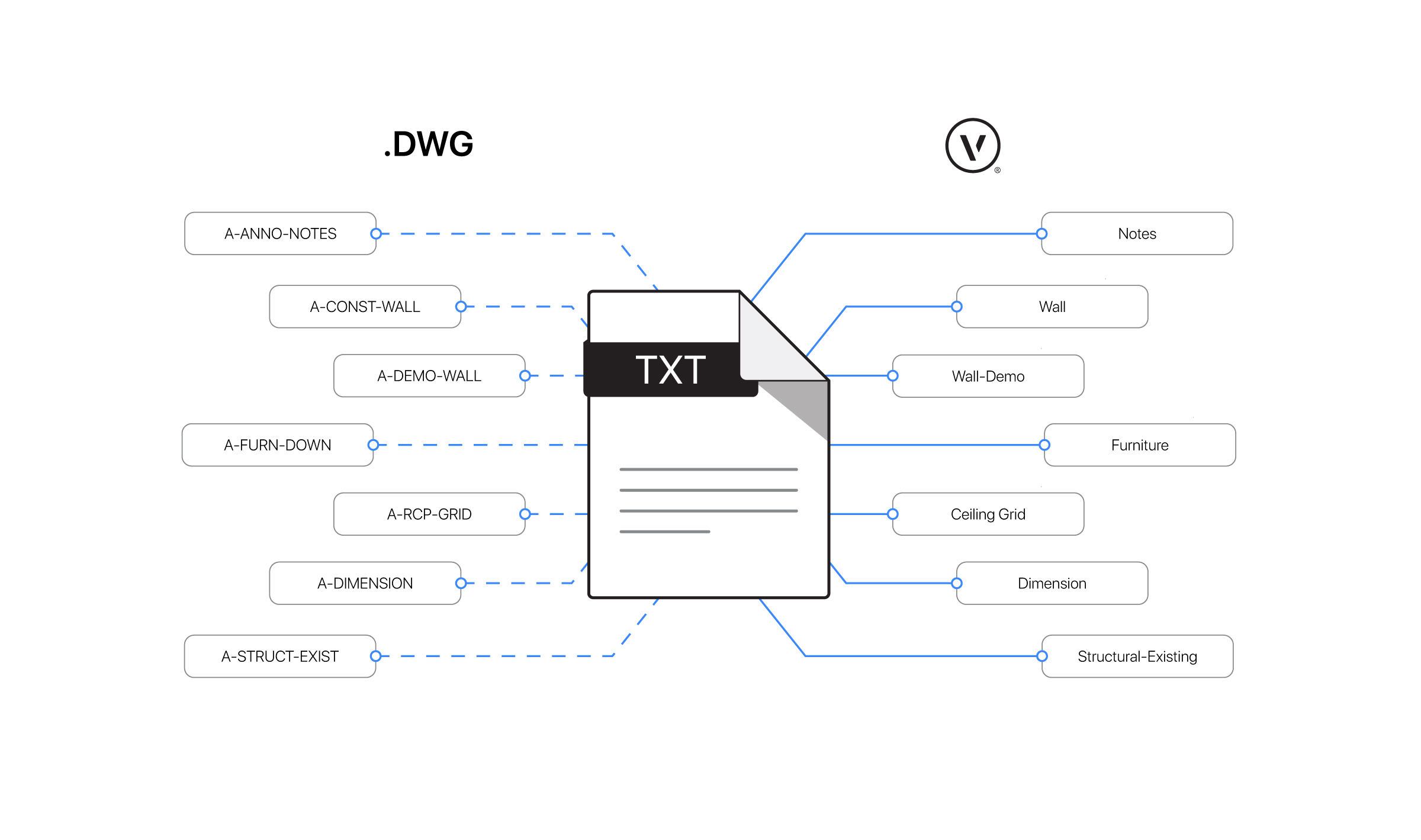


DWG files are necessary to be able to work with whether you work in architecture, landscape architecture/design, or entertainment design. This file format is an industry standard that most AEC software supports, and Vectorworks is no exception.
You’re likely aware of Vectorworks’ ability to import, export, and reference DWG files. But let’s take it a step further — what are some of the key things to consider when working with these files?

7 Questions for Success with DWG Collaboration in Vectorworks
Here’s a list of seven questions to ask yourself before beginning collaboration with consultants via DWG files.
What software version is your consultant using?
This is important to know because the collaboration process could vary depending on which software your consultant is using. Vectorworks supports several formats and previous versions of AutoCAD back to R12.
Will you receive the file once, or will it be a continuous back-and-forth process? How often will you receive updated files?
Answering this question gives you a greater understanding of the project process at large. If a structural or civil engineer shares a developed model later in the design process that will not change, for example, you might be able to simply import the file. If they share a conceptual model earlier in the design process, then you might want to reference the file so that it receives updates as your consultant makes them.
What is the purpose of the information you’ll be exchanging?
If the information is being shared in the conceptual phase of a smaller 2D project, it might not need to be as detailed or graphically rich to serve its purpose. If the information is contributing to a collaborative 3D model, it’ll need to be detailed, precise, or even visually appealing. Establishing whether the project will be 2D or 3D is typically decided at project kickoff.
The key here is communication. What is the best method to share design intent with the consultant so they can use that information as a background for their design process?
How will the information be used by the party that receives it?
It’s important to know exactly what you or the consultant will be doing with the exchanged information. This allows both parties to better tailor their files through respective export and import settings to the use case on the other end, streamlining the collaboration process.
What are the DWG drawing units?
This is critical to verify for both imported and referenced DWG files. In cases where the consultant’s file doesn’t indicate drawing units, you can simply ask the file author or you can identify a reference dimension — something you know the real-world size of, such as a door, which is generally three feet or 900 millimeters wide, or a parking space, which is generally nine feet or 2.74 meters wide.
Vectorworks attempts to discern units upon import, but it’s still good to confirm to avoid surprises.
What is the type of information you’ll be exchanging? Will it be 2D drawings and/or 3D models?
You want to avoid the case where you or a consultant is blindsided by information they weren’t expecting. If a consultant only works in 2D, they likely won’t find your 3D model helpful. Likewise, if you’re receiving terrain information, a flattened 2D topography plan could mean extra work translating it to 3D geometry. Either way, you can handle what’s needed with Vectorworks.
Is the file georeferenced and, if so, which coordinate reference system is being used?
Georeferencing is a great way to place the project in the real world, but a project’s georeferenced base point is just one attribute in properly maintaining its georeferencing. Building position, orientation, and documentation layout can all be affected if the receiver of the georeferenced DWG files cannot properly maintain them.
Fortunately, Vectorworks designers can rest assured that using the same geographical coordinates and angle to true north means this should be handled properly in the file. Vectorworks has the ability to read the coordinate system of an imported or referenced DWG file, and likewise has the ability to embed this information on export.
Get Your Guide to DWG File Format Collaboration with Vectorworks
Answering the questions in this blog provides a solid baseline for establishing file exchange protocols with consultants. If you’re looking for more detailed information about collaborating with DWG files, check out this guide that explores how to do it in depth.

